You are using an out of date browser. It may not display this or other websites correctly.
You should upgrade or use an alternative browser.
You should upgrade or use an alternative browser.
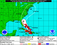
What a Bummer - Hurriance Matthew
- Thread starter CPP
- Start date
the professor
Well-known member
Lets hope so
Shadowfax
Well-known member
Good luck to anyone in it's path. We will get crappy weather here for sure but not the brunt of it.
jdandy
New member
Chris.......Batten down the hatches. It looks like the Palm Coast may take a beating from hurricane Matthew. I have friends in Port St.Lucie who are very nervous about the current projected path. Matthew has slowed down to 120 mph sustained winds so perhaps the upper level winds will manage to keep the eye wall off the coastline. I sure hope so.

a.wayne
Well-known member
Current models dont show the eye going on shore in Fla , my friends in the Bahamas wont be so lucky ...
CPP
Active member
- Thread Author
- #6
Chris.......Batten down the hatches. It looks like the Palm Coast may take a beating from hurricane Matthew. I have friends in Port St.Lucie who are very nervous about the current projected path. Matthew has slowed down to 120 mph sustained winds so perhaps the upper level winds will manage to keep the eye wall off the coastline. I sure hope so.
Yep in my county they are calling for a volunteer evacuation for Thursday morning with a mandatory coming later Thursday. They will close the bridges and then your stuck on the barrier islands if you stay. But it all depends on how close this thing gets to shore once it gets to Merritt Island on up and if it takes a NNE turn after Merritt Island.
My hatches are tight, we have our sandbags and doors secure but if there is a surge all bets are off and then its insurance and flood insurance filings. I don't need a stinking storm surge or high winds. Just let it go way off shore.
Hey Wayne, the eye doesn't have to go on shore when your taking about a cat 3 or 4 storm. The winds and the water pushed towards shore will do enough damage.
a.wayne
Well-known member
May i suggest you get out and head west , let the ins co fight it out, it's sure as hell not worth it trying to ride out a storm surge.
Stay safe Chris.
Sent from my iPhone using Tapatalk
Sent from my iPhone using Tapatalk
cmalak
Active member
- Joined
- Apr 10, 2013
- Messages
- 2,304
Good luck to all ASers in the South East but especially those in the direct path of Mathew. Hoping that Mathew does not cause any physical harm or damage to any of you and to the South East at large. Sending you all positive vibes and best wishes.
Mack
New member
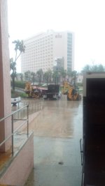
I am in Broward County and while the winds are brisk at times the real stuff won't roll in until late night. I have done all that I can do for the house. On the other hand my daughter and son in law are within 40 miles of the estimated land fall so I'll be watching them closely.
Mac
Mac
annapolis Raider
Member
- Joined
- Dec 14, 2013
- Messages
- 386
Stay Safe everyone.... I'm in Miami... but evacuated out for now
MDP
Behavior Moderator (be nice police!)
Please be safe Chris!
jdandy
New member
Looks like Miami and Fort Lauderdale will dodge the bullet. The eye wall just took a turn to a more northern track so there is a possibility the most severe winds will remain offshore. There will still be tremendous storm surge as the high winds push the ocean water onshore. It is storm surge that kills more people than the wind.
Mack
New member
South Florida is breathing easier but the folks on the Treasure Coast need some luck now!
MDP
Behavior Moderator (be nice police!)
All of those people are in my prayers.
a.wayne
Well-known member
MDP
Behavior Moderator (be nice police!)
I hope we hear from our Florida members soon.
My sister is here with us after leaving Charleston.
My sister is here with us after leaving Charleston.
annapolis Raider
Member
- Joined
- Dec 14, 2013
- Messages
- 386
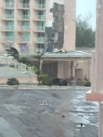
Back in Miami beach here. Minimal damage in my area. Hope the storm stays offshore, amazingly lucky so far.....
jdandy
New member
I am relieved this morning to see the hurricane eye wall has remained offshore. This has helped reduce coastal residents losses from catastrophic wind and storm surge damage. The eye wall is just off Daytona Beach right now and fortunately the wind speed has dropped to around 100 mph around the eye. I am south of Live Oak, Florida and we are seeing wind gusts of 15 to 20 mph but not sustained, and rain. It will probably get a bit more windy and rainy here as the eye moves up the coast to Jacksonville. No power losses in my area at this time.