Puma Cat
Well-known member
- Thread Author
- #1
I know that members on the East Coast have been dealing with the after-effects of recent Hurricanes e.g. Beryl and Milton and now California & the West Coast have been getting slammed by what is known as a “bomb cyclone” from an atmospheric river since Wednesday. Acc. to NOAA, a bomb cyclone is the result of “bombogenesis” from the Fujiwhara Effect*
From NOAA: “Bombogenesis, a term used by meteorologists, occurs when a midlatitude (the latitudes between the tropics and polar regions) cyclone rapidly intensifies, or strengthens, over a 24 hour period. This intensification is represented by a drop in millibars, a measurement of pressure used in meteorology. The intensification required to classify as "bombogenesis" varies by latitude. At 60 degrees latitude, it is a drop of at least 24 millibars (24 hectopascals) over 24 hours. At the latitude of New York City, the required pressure drop is about 17.8 millibars (17.8 hectopascals) over 24 hours. Bombogenesis can happen when a cold air mass collides with a warm air mass, such as air over warm ocean waters. It is popularly referred to as a bomb cyclone.”
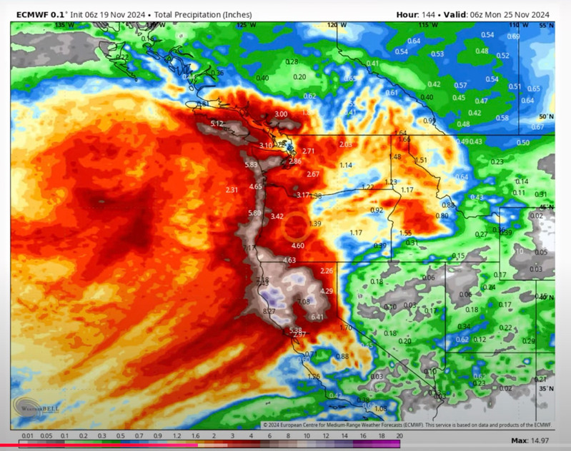
This graphic represents what the “European” weather model was predicting on Wednesday, two days ago, that the bomb cyclone currently hitting Northern California was projected to look like by Monday, Nov 25.

Turns out that the European model projection was an underestimate. Here’s rainfall totals in CA North Bay counties since Wednesday:
Venado, W. of Healdsburg: 20.93”, Glen Ellen: 22.0” W. Healdsburg: 19.15”, Cazadero: 17.01”,St. Helena: 12.32”, Santa Rosa: 11.27”, Calistoga: 13.44”, Guerneville: 11.82”, Yountville: 8.98”, San Anselmo: 8.33”, Sonoma: 7.88”, Novato: 5.28”, Petaluma: 5.27” and Napa: 4.88”. The Russian River is currently at 28.58 ft, flooding occurs at 32 ft, and the River is predicted to rise to 34’, potentially causing flooding in downtown Guerneville, CA. As a result, NOAA has issued flood warnings for these northern Bay Area counties.
Here’s what the European is projecting today: ~3.5” of rain in the main Bay Area by Wednesday next week:

All said, this has been one of the craziest weather years I can remember, and we’re not even fully into the rainy season yet, and I'll add that I have friends living in the Bainbridge Island part of Washington State and they have have been slammed by rain and heavy winds as well, and are dealing downed tall trees on their property.
I’ll just close by saying that this is what happens when “Thermodynamics has it’s way with you”. It ain’t over yet, so stay tuned and those of you in California and the West Coast, stay safe, gang.
*-Fujiwhara Effect: When two hurricanes spinning in the same direction pass close enough to each other, they begin an intense dance around their common center. If one hurricane is a lot stronger than the other, the smaller one will orbit it and eventually come crashing into its vortex to be absorbed. Two storms closer in strength can gravitate towards each other until they reach a common point and merge, or merely spin each other around for a while before shooting off on their own paths. In rare occasions, the effect is additive when the hurricanes come together, resulting in one larger storm instead of two smaller ones.
From NOAA: “Bombogenesis, a term used by meteorologists, occurs when a midlatitude (the latitudes between the tropics and polar regions) cyclone rapidly intensifies, or strengthens, over a 24 hour period. This intensification is represented by a drop in millibars, a measurement of pressure used in meteorology. The intensification required to classify as "bombogenesis" varies by latitude. At 60 degrees latitude, it is a drop of at least 24 millibars (24 hectopascals) over 24 hours. At the latitude of New York City, the required pressure drop is about 17.8 millibars (17.8 hectopascals) over 24 hours. Bombogenesis can happen when a cold air mass collides with a warm air mass, such as air over warm ocean waters. It is popularly referred to as a bomb cyclone.”
This graphic represents what the “European” weather model was predicting on Wednesday, two days ago, that the bomb cyclone currently hitting Northern California was projected to look like by Monday, Nov 25.

Turns out that the European model projection was an underestimate. Here’s rainfall totals in CA North Bay counties since Wednesday:
Venado, W. of Healdsburg: 20.93”, Glen Ellen: 22.0” W. Healdsburg: 19.15”, Cazadero: 17.01”,St. Helena: 12.32”, Santa Rosa: 11.27”, Calistoga: 13.44”, Guerneville: 11.82”, Yountville: 8.98”, San Anselmo: 8.33”, Sonoma: 7.88”, Novato: 5.28”, Petaluma: 5.27” and Napa: 4.88”. The Russian River is currently at 28.58 ft, flooding occurs at 32 ft, and the River is predicted to rise to 34’, potentially causing flooding in downtown Guerneville, CA. As a result, NOAA has issued flood warnings for these northern Bay Area counties.
Here’s what the European is projecting today: ~3.5” of rain in the main Bay Area by Wednesday next week:

All said, this has been one of the craziest weather years I can remember, and we’re not even fully into the rainy season yet, and I'll add that I have friends living in the Bainbridge Island part of Washington State and they have have been slammed by rain and heavy winds as well, and are dealing downed tall trees on their property.
I’ll just close by saying that this is what happens when “Thermodynamics has it’s way with you”. It ain’t over yet, so stay tuned and those of you in California and the West Coast, stay safe, gang.
*-Fujiwhara Effect: When two hurricanes spinning in the same direction pass close enough to each other, they begin an intense dance around their common center. If one hurricane is a lot stronger than the other, the smaller one will orbit it and eventually come crashing into its vortex to be absorbed. Two storms closer in strength can gravitate towards each other until they reach a common point and merge, or merely spin each other around for a while before shooting off on their own paths. In rare occasions, the effect is additive when the hurricanes come together, resulting in one larger storm instead of two smaller ones.
